|  Interesting
route running through the centuries-old forest of Vallombrosa in
the Natural Reserve of the same name. It is an easy route
which sticks to forest roads, but as there are lots of these, there could
be orientation problems. Interesting
route running through the centuries-old forest of Vallombrosa in
the Natural Reserve of the same name. It is an easy route
which sticks to forest roads, but as there are lots of these, there could
be orientation problems.
When you arrive at Consuma, those coming from Florence will see the red and white
signs of the CAI no. 00 path on the right of the state road. Following these
signs in the car, take a narrow asphalt road that climbs until it reaches some
small villas. After passing them, the road turns into a track. Leave the car
here, put on your skis and set out, following the red and white signals. The
route takes you into the wood and you immediately come to a crossroads with a
tabernacle. Go right along the unpaved track that goes into the thick fir wood
that cloaks the ridge. Carry on along here for about 2 km (there is no possibility
of going wrong) until you reach the Croce di Ribona, where you leave the ridge
track and go right along an unpaved track closed off by a bar. This immediately
begins to descend (ignore a road to the right) and soon brings you to a junction
near a metal shack. If you carry straight on, you descend immediately to the
Consuma–Vallombrosa road, which has been closed by a landslide for the
last few years and so is not maintained (the left branch take you across one
of the most beautiful corners of the Forest of Vallombrosa to the abbey). If,
on the other hand, you go left, passing in front of the shack, the route does
a wide loop in the wood, running along a gentle, slightly rising path that gradually
draws closer to the Fosso del Bifolco. After doing a wide semi-circle to the
right around the head of the stream, you come to a junction. Here, going left,
you rise quickly to the Vallombrosa–Secchieta paved road (maintained in
winter). Taking the road to the right you go downhill, keeping above the stream
until you come to another junction. From here all routes lead to to the Consuma–Vallombrosa
road (not maintained in winter and excellent for cross-country skiing), but the
one going off to the left is the most interesting; this takes in Metato and the
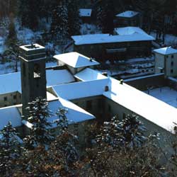
Capanna Massa al Monte, finally joining the main road. The abbey of Vallombrosa
is along here to the left. You can either return the way you came or along the
Consuma–Vallombrosa road.
| Distance |
20 km (round trip) |
| Difference in height |
250 m |
| Time |
5.30 hours |
| Level of difficulty |
Easy |
| Map |
Multigraphic 1:25.000 "Massiccio del
Pratomagno" |
| Suggested period |
January/February |
| Rest point/accommodation |
Abbey guest house, tel. 055/862074 |
| Getting there |
The Consuma can be reached from Florence
and Arezzo along SS. no. 70 which links the two provincial capitals. |
|
 Skiing round the Apennine hermitages
 Photo Gallery: The tour