| 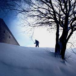 Panoramic route along a forest road that climbs to the ridge of the
Alpe di Catenaia. Inside the small Eremo della Casella there
is a small room with a fireplace, tables and benches, which can be
used as a shelter in case of emergency.
Panoramic route along a forest road that climbs to the ridge of the
Alpe di Catenaia. Inside the small Eremo della Casella there
is a small room with a fireplace, tables and benches, which can be
used as a shelter in case of emergency.
The starting point is on the road from Caprese Michelangelo to Chiusi della Verna
near S. Andrea a Sovaggio. Here, on the left of the paved road, there is an unpaved
track marked with the red and white signs of footpath no. 039 (not very evident
in high snow). Take this track (with your skis on), ignore another track leading
off it to the left and carry on uphill alongside a fence. Although this first
stretch is the most tiring part of the whole route, it allows you to quickly
reach an altittude of over 1000m. When you come to a broad flat area, go diagonally
to the left keeping to the main track, which will bring you to the Alpe di Catenaia
ridge at the Croce del Varco. Take the track to the left, which keeps to the
ridge and climbs to the Croce della Malcima and then the summit of Monte Foresto.
A final level stretch leads to a broad open area and the Eremo della Casella,
surrounded by centuries-old beeches. Retrace your steps to return to the starting
point.
| Distance |
11 km (round trip) |
| Difference in height |
290 m |
| Time |
3.30 hours |
| Level of difficulty |
Easy |
| Map |
SELCA 1:25.000 "Tra L'Arno e il
Tevere" |
| Suggested period |
January/February |
| Rest point/accommodation |
A specially designated room in the
hermitage |
| Getting there |
From Arezzo take the road for the Valico
di Scheggia mountain pass as far as Anghiari and from here take the
provincial
road for Caprese Michelangelo. From Cesena, take the SS. no. 3 bis
(much of it dual carriageway). Exit at Pieve S. Stefano and take the
SS. no. 208 towards La Verna. Along here you will find signs for
Caprese Michelangelo. |
|
 Skiing round the Apennine hermitages
 Photo Gallery: The tour