 Cappella
M. Piglionico (1100m) - Pania Secca (1711m) - Rifugio Rossi (1600m) - Pania
della Croce (1859m) - Borra di Canala/junction of path nos. 139 and127 (1010m)
- Cappella M. Piglionico. Cappella
M. Piglionico (1100m) - Pania Secca (1711m) - Rifugio Rossi (1600m) - Pania
della Croce (1859m) - Borra di Canala/junction of path nos. 139 and127 (1010m)
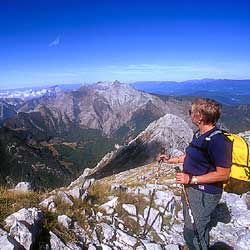
- Cappella M. Piglionico. This is one of the classic routes of the
Apuans, one which has retained its interest and fascination and allows
you to enter into the very heart of these majestic Tuscan Alps. Its karst
topography and wide, breath-taking views contribute to make it one of
the most beautiful excursions in the region.
Leave the car near the Monte Piglionico chapel and walk along the unpaved
path marked CAI 7/127. Soon you come to a junction where you go left (no.
7) along an old mule track used by charcoal burners that climbs through
a beech wood until it reaches an open meadow area below the Rifugio Rossi,
which is already visible. When you get to a junction, turn left and descend
a little to a saddle and then immediately start climbing again (taking
care on the rocky sections) to the ridge which ascends steeply to the
summit of the Pania Secca.
Retracing your steps, climb to the Rifugio Rossi (open all the year round)
and then carry on until you reach a saddle at 1611 metres where there
is a clearly visible cluster of signals. Take the path (no. 126) that
steeply climbs the Vallone dell' Inferno (might Dante have been inspired
by it when writing The Divine Comedy?), and after crossing scree and karst
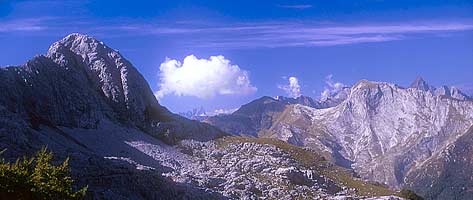
rock you get to the ridge which leads off to the left to the large cross
marking the summit of the Pania della Croce. Having admired the broad
360-degree view which stretches from the Arno valley to the sea, all the
way to Corsica and sometimes the Maritime Alps, retrace your steps till
you reach the junction at 1611 metres. This time, take the path to the
left which goes down the lunar valley of the Borra di Canala. Taking great
care as you descend the steep stony path (no. 139), you come to the most
atmospheric part of the walk. The arid valley, which is cut out from the
slopes of the Pizzo delle Saette, is a small buttress. Jumping from rock
to rock, descend to a wood and then continue descending till you reach
the junction with path 127. Bending sharply to the right, follow the contour
line and skirt the buttress by means of a few little ups and downs. The
narrow path cut in the mountain slope brings you to just below the tabernacle
from which you started. A few metres' climb and you are back to where
you started.
| Access |
coming by car from Gallicano in the Garfagnana,
follow the signs for the Rifugio Rossi and the Alpe di S. Antonio.
At the Alpe di S. Antonio junction, take the unpaved track to the
left which soon brings you to a chapel dedicated to the partisans
who fought and died during the war. |
| Time required |
5 hours |
| Difference in height |
750 m |
| Difficulty |
E E |
| Maps |
S.EL.CA. scale 1:25,000 accompanying the
book
Garfagnana Trekking Multigraphic - Alpi Apuane |
| Characteristics |
steep, difficult paths; sweeping views |
| Best season |
late spring/early summer and early autumn |
|
 www.terraditoscana.com