|
 When
you reach the small village of Castagno d'Andrea in the Mugello, continue
along the asphalt road (unpaved in some places) that climbs in a series
of wide bends to the Borbotto bivouac (open all the year round; spring
close by). When
you reach the small village of Castagno d'Andrea in the Mugello, continue
along the asphalt road (unpaved in some places) that climbs in a series
of wide bends to the Borbotto bivouac (open all the year round; spring
close by).
Park the car and walk past the bar blocking car access and along the forest
road into the beautiful forest of the national park. After just 400m,
leave the forest road and take a path (G.E.A. signs) on the right, which
begins to climb, steeply in places, through the beech wood covering the
steep slopes of Monte Falterona. Taking wide bends, the path finally reaches
a crest. Walk along it till you come to a panoramic view of the Scalicci
di Piancancelli area, which gets its name from the geological shape of
the rocks, which consist of layers of sandstone structured in such a way
that they look like enormous stairs.
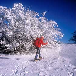
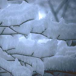
The final stretch of the path, which ends up near the wooden cross on
the summit of Monte Falterona (1654m) is quite difficult, because the
weight of snow on the fir tree saplings unwisely planted on the summit
bends them over, and it can be hard work getting through.
 After taking in the view of the entire alluvial basin of the Mugello,
go left and drop down to a small road on the Casentino side, which soon
starts climbing again up to the panoramic peak of Monte Falco (1658m).
Head directly south, carrying on along the watershed till you get to the
arrival point of a ski lift for the only ski facilities in the area. Skirt
round an airforce meteorological station, and follow the path along the
crest until you finally arrive at the extensive fields of the Burraia;
if you're in a group and have telephoned Angiolo Ricci of the local mountain
rescue unit in advance, you can get the old refuge here opened up, which
dates back to the time of the Grand Duchy. After having had lunch under
shelter, carry on southwards till you descend to the Passo della Calla
(1296m). From the pass, after thirty or forty metres, take an old mule
track (which also dates back to the period of the Grand Duchy) on the
right which descends to a recently-restored bridge and then climbs for
a short stretch to the village of Campigna at 1068m (Bar-Hotel-Ristorante
Granduca - tel. 0543/980051; Hotel Lo Scoiattolo - tel. 0543/980052).
After taking in the view of the entire alluvial basin of the Mugello,
go left and drop down to a small road on the Casentino side, which soon
starts climbing again up to the panoramic peak of Monte Falco (1658m).
Head directly south, carrying on along the watershed till you get to the
arrival point of a ski lift for the only ski facilities in the area. Skirt
round an airforce meteorological station, and follow the path along the
crest until you finally arrive at the extensive fields of the Burraia;
if you're in a group and have telephoned Angiolo Ricci of the local mountain
rescue unit in advance, you can get the old refuge here opened up, which
dates back to the time of the Grand Duchy. After having had lunch under
shelter, carry on southwards till you descend to the Passo della Calla
(1296m). From the pass, after thirty or forty metres, take an old mule
track (which also dates back to the period of the Grand Duchy) on the
right which descends to a recently-restored bridge and then climbs for
a short stretch to the village of Campigna at 1068m (Bar-Hotel-Ristorante
Granduca - tel. 0543/980051; Hotel Lo Scoiattolo - tel. 0543/980052).
If you walk on for about another two kilometres on the quiet road descending
towards S. Sofia, you come to a junction where there's an unpaved road
on the left that goes downhill to the Agriturismo Il Poderose, where the
friendly Lorenza will give you a warm welcome and put you up very comfortably!
| Access |
Da Firenze con la S.S.n° 67 per Forlì
fino a S. Godenzo - bivio per Castagno D'Andrea.
Da Forlì con la S.S.n°67 per Firenze, via passo del Muraglione
fino a S. Godenzo - bivio per Castagno D'Andrea. |
| Time required |
Ore 6 |
| Difference in height |
500 m. |
| Difficulty |
E, su sentieri a tratti ripidi ma segnalati
(segnavia G.E.A.) |
| Salite Dure |
|
| Maps |
Itinerari naturalistici -S.EL.CA./ Comune
di Poppi - 1.15.000 - Cartografia 1:30.000 allegata al volume G.E.A.
- Multigraphic carta del Casentino - Carta del Casentino 1:50000 S.EL.C.A.
- Le Mappe di Airone 1:65.000 Giorgio Mondadori |
| Info |
Ufficio del Parco di S. Godenzo(Fi) tel.
0558375121 |
|
 Skiing round the Apennine hermitages
 Photo Gallery: The tour