| 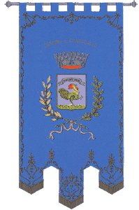 Inhabitants in 1991: 2.536
 The
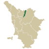
municipal territory of Cantagallo extends for 94,92 square kilometres
between the right side of the Bisenzio and the western Limentra valley,
on territory mostly mountainous, on the spur of the Appenninica
chain. Feudal land, it was instituted as Seat of the community by Grand
Duke Pietro Leopoldo in 1774; it reached its present day aspect in 1984
with the aggregation of an area taken from the municipality of Barberino
di Mugello. The
municipal territory of Cantagallo extends for 94,92 square kilometres
between the right side of the Bisenzio and the western Limentra valley,
on territory mostly mountainous, on the spur of the Appenninica
chain. Feudal land, it was instituted as Seat of the community by Grand
Duke Pietro Leopoldo in 1774; it reached its present day aspect in 1984
with the aggregation of an area taken from the municipality of Barberino
di Mugello.
The town of Cantagallo, with its Alpine aspect, overlooked by a
chain of mountains which almost hide it, seems to have also been hidden
for centuries from the great events of history. Little is the news
which comes down to us about this town and the districts of its territory.
Until the XIV century it was the dominion of a small local feudal group,
the Nobles of Cantagallo, vassals to the Vernio Counts, then it became
part of the Firenze jurisdiction. On the contrary, in the Medieval
the capital Luicciana was under the civil and political jurisdiction of
Pistoia and had the Seat of Podesta office of the Val di Bisenzio, as
is shown in certain documents from the end of the 1300s. Another locality
of a certain historical importance is Trebbio (in ancient times
Treppio), in the Medieval it was Seat of a parish church dependent to
the diocese of Bologna and object of a long dispute between Pistoia and
the Holy See, a dispute terminated with the acquisition of Trebbio and
other surrounding castles by Pistoia in 1319, in the times of the Grand
Duchy there was a customs house at Trebbio.
Historical info reproduced upon authorization of Regione Toscana - Dipartimento della Presidenza E Affari Legislativi e Giuridici
Translated by Ann Mountford |
 www.terraditoscana.com