 |
1.
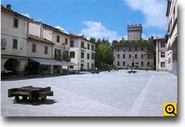
A view of Piazza Agnolo.
In the back the rock, seat of the city hall |
|
The
main part of the surviving "Romagna toscana", that means
the grand-ducal "Valli Transappennine", is occupied by
the communal territory of Firenzuola, one of the most
extended territory of the region. The boundaries are represented
by:Borgo San Lorenzo, Scarperia, Barberino, Castiglione
dei pepoli, Palazzuolo sul Senio, Castel del Rio, Monterenzio,
Monghidoro e san benedetto Val di Sambro.
This
territory occupies the high basin of the river Santerno,
the main right affluent of the river Reno, and it extends
on the adriatic side of Apennines form Passo della Futa
to Monte Paganino.This area has been always interested
by the road conditions between the valley of Florence
and the region Romagna, and so Pianura Padana. In the
territory of Firenzuola there are the current Passo della
Futa, the cross of Osteria Bruciata, which is now abandoned
but which was very famous in the middle Age, and the Giogo
of Scarperia. From all these passes it is possible to
reach the Passo della Raticosa along the road to Bologna,
or it is possible to go down along the valley of Santerno
to reach Imola. The foundation of Firenzuola, in 1300,
is linked to its road function, as well as the foundation
of the parishes of Cornacchiaia, Camaggiore e Bordignano
which, with their limited number of dependent churches,
also testify the relative inhospitality of the area. The
parish of Cornacchiaia, which is situated on the northern
side of Passo dell'Osteria Bruciata, seems to complete
the function that was carried out, on the southern side,
by the parish of Sant'Agata, not far from Scarperia.
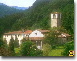 |
| 3.
Cornacchiaia - The parish |
|
It
is not a concidence the fact that two churches, situated
on the opposite side of the same mountain, have, more
or less, the same features in their architectural structures.
Except the changes, the parish of San Giovanni a Cornacchiaia
presents the same number of "valichi" between
the nave and the aisles, and this is the same structure
of the parish of Sant'Agata.
The
territory of high Mugello and the correspondant side of
Romagnoli Apennines were, since the High Middle Age, "signoria"
of the Ubaldini family. The power of this family in this
area was so strong that a part of the correspondant mountain
chain was called "Alpes Ubaldinorum", at least
until the beginning of 1300. After this period, when Florence
dominated this area, the part of Apennines mentioned above
represented the Alpe Fiorentina.
The
power of Ubaldini and that of the members of the same
faction was established upon a great numbers of castles,
from which these families could control the various
 |
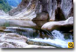
| 4.
The Santerno at Ferniana |
|
roads,
which crossed the Apennines (the most important one was
the pass of Osteria Bruciata). Today most of these castles
are ruins.
 |
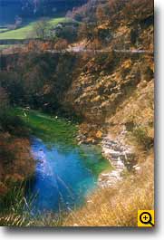
| 2.
The Santerno nearby "Ca' Bassa" |
|
The
power of Ubaldini on this area was practically absolute,
and every villages or resorts was owned by this powerful
faction.
The
power of Ubaldini represented a real obstacle for the
Republic of Florence as it concerns the control on this
territory, especially relating to the negative consequences
of the road conditions towards the Bolognese, so that
in 1306 the foundation of two "terre nuove"
was decided : one of them in "Mucello" Scarperia,
and the other "ultra Alpes", that means firenzuola.
Some
years before, in 1299, in Valdarno Superiore, some new
settlements were founded in order to cancel the feudal
powerful: this annulment was made not with military action,
but with the social and economical restructuration of
the human potential of the countryside, in order to favour
the dominating town; this kind of intervention was similar
to the one carried out in Mugello with the foundation
of Scarperia and Firenzuola. The new settlements of Firenzuola
was inhabitated by the inhabitants of the resorts of Tirli
and Bordigliano, which represented two of the most powerful
settlements controlled by the Ubaldini.